Location: Milton Keynes
Service: Topographical Survey, Drone Survey
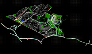
Interlocks Surveys was commissioned to survey a total of 217 ha (536 acres) of land earmarked for development near Milton Keynes, including multiple highways and a stretch of the M1.
Given the scale of the project and accessibility challenges in some areas a combination of traditional methods and drone photogrammetry were employed to ensure safe and comprehensive coverage of the area.
A dedicated project manager was allocated to the project and a staged delivery schedule agreed with the client in order to facilitate progress in other parts of the project and ensure that the project ran according to schedule.